Satellite Technology in Agriculture
Satellite technology has revolutionised agriculture, empowering farmers to make data-driven decisions, optimise resources, and monitor crop health over large areas. This technology enables precision agriculture practices, which can lead to improved yields and more efficient use of inputs such as water and fertilisers. As satellite technology continues to advance, we can expect even more precise and actionable data for farmers. The first artificial satellite, Sputnik 1, was launched in 1957. By early 2021, approximately 3,400 operational satellites were orbiting Earth. Remarkably, this number has more than doubled in just two years, with over 7,500 operational satellites by the end of 2022 [1]. This surge is due to both cheaper, smaller satellites deployed in large constellations and plummeting launch costs, which have decreased from $85,000 per kilogram in the 1980s to around $3,000 today [2], making satellite data increasingly accessible.
Eyes in the Sky: How Satellites Aid Farmers
Satellites orbiting the Earth collect a wealth of data that, when analysed, provide valuable insights for farmers. You can access this information right now for free through the Copernicus browser and explore some of the following benefits:
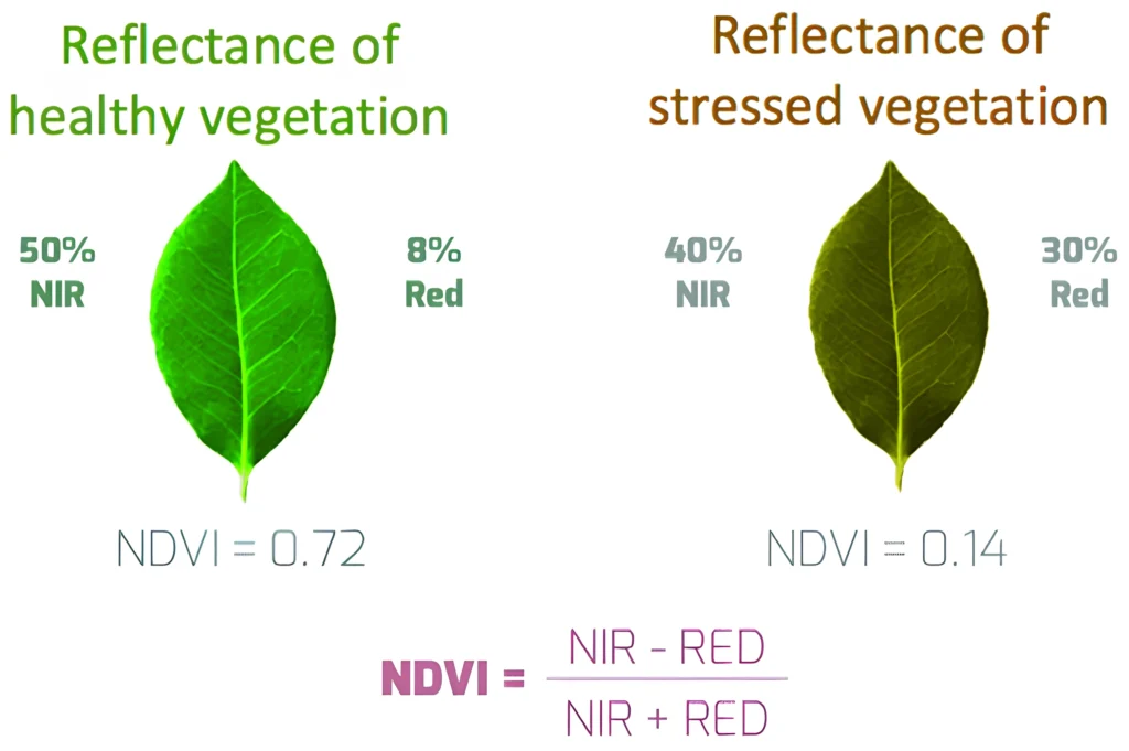
- Crop Health Monitoring: Multispectral sensors detect plant health variations across vast areas. The Normalized Difference Vegetation Index (NDVI), a common metric for vegetation health, reveals stress from pests, diseases, or nutrient deficiencies (Figure 1).
- Irrigation Management: Thermal sensors measure land surface temperatures, identifying water stress areas. This enables efficient irrigation, especially in water-scarce regions.
- Yield Prediction: Tracking crop development over time helps predict yields accurately, aiding harvest planning and market forecasting.
- Soil Quality Assessment: Spectral analysis of satellite imagery reveals soil composition and quality, informing decisions about fertilisation and crop rotation.

Limitations and Challenges
While satellite technology offers numerous benefits, it’s important to understand its limitations:
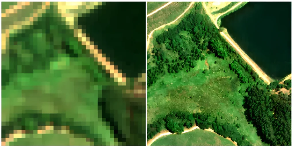
- Resolution Limits: Even the highest resolution satellite images (0.5m) can’t detect some ground-level details crucial for farming. Lower-resolution images (3-5m) offer more frequent updates and are cheaper but miss even more details. The Copernicus browser is free but only offers 10m resolution (Figure 2). Advancements in AI may enable analysing valuable information even at these lower resolutions, detecting nuanced crop variations despite the resolution restrictions.
- Atmospheric Interference: Clouds and atmospheric conditions can distort or block satellite imagery. Correction algorithms help, but thick cloud cover can cause data gaps for optical satellites. Some radar satellites can penetrate clouds but provide different data types.
- Data Interpretation: Satellite imagery can be complex to understand. AI and machine learning are helping by turning intricate data into clear, actionable insights for farmers.
- Accessibility: While costs are decreasing, high-resolution imagery and analytics can still be expensive. Additionally, the digital literacy required to effectively use satellite data tools can be a barrier for some farmers, particularly in regions with limited exposure to advanced agricultural technologies.
The Future of Satellite Technology in Agriculture
Satellite technology’s key advantage is remote monitoring, which is crucial for Australia’s vast, diverse agricultural landscapes. From Western Australia’s wheat belts to Queensland’s sugar cane fields, satellites enable efficient management and timely decision-making in isolated operations. Integration with IoT sensors and AI-driven analytics provides the opportunity to derive even deeper insights directly to farmers without specialist interpretation. This transformative technology could help increase farm efficiency, productivity, and sustainability. If you’re interested in learning more, feel free to contact the author for additional information.
References
[1] Union of Concerned Scientists. (2023). “UCS Satellite Database”. https://www.ucsusa.org/resources/satellite-database
[2] Jones, H. (2020). The Recent Large Reduction in Space Launch Cost. NASA Technical Reports Server. Retrieved from https://ntrs.nasa.gov/citations/20200001093.

